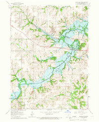
1965 Map of Knoxville SW
USGS Topo · Published 1966About this map
Lake Red Rock dominates this mid-1960s landscape, with its Normal Pool Elevation 725 clearly delineated. The map reveals a transition in land use, where the sprawling reservoir meets established agricultural and industrial infrastructure. The presence of multiple Strip Mines indicates the region's active coal extraction during this era, while the winding course of White Breast Creek and Butcher Creek define the underlying topography.
Find a feature on this map
24 named features on this map. Tap any name to fly to it.
Don’t see what you’re looking for? This feature index may not catch every label — zoom into the map to look around manually.
Map Details
Editions of this 1965 Knoxville SW Map
This is the sole edition of this map. No revisions or reprints were ever made.
Other maps of this area

1909 · Knoxville
USGS Topo · 1:62,500

1910 · Milo
USGS Topo · 1:62,500

1912 · Knoxville
USGS Topo · 1:62,500

1918 · Chariton
USGS Topo · 1:62,500

1924 · Melcher
USGS Topo · 1:62,500

1954 · Des Moines
USGS Topo · 1:250,000

1956 · Des Moines
USGS Topo · 1:250,000

1957 · Des Moines
USGS Topo · 1:250,000

1965 · Pleasantville
USGS Topo · 1:24,000

1965 · Knoxville NW
USGS Topo · 1:24,000