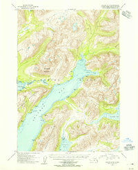
1954 Map of Kodiak A-6
USGS Topo · Published 1955About this map
The Kodiak National Wildlife Refuge encompasses the entire land area shown here, revealing a maritime wilderness defined by deep fjords and glaciated peaks. The waters of Deadman Bay slice through the center of the sheet, separating the Moser Peninsula from the Hepburn Peninsula. This survey, compiled from early 1950s aerial photography, documents a sparse human presence restricted to isolated shoreline Cabin and Cabins locations, including a cluster at Alpine Cove.
Find a feature on this map
28 named features on this map. Tap any name to fly to it.
Don’t see what you’re looking for? This feature index may not catch every label — zoom into the map to look around manually.
Map Details
Editions of this 1954 Kodiak A-6 Map
This is the sole edition of this map. No revisions or reprints were ever made.
Other maps of this area

1951 · Kaguyak
USGS Topo · 1:250,000

1951 · Trinity Islands
USGS Topo · 1:250,000

1951 · Karluk
USGS Topo · 1:250,000

1952 · Kodiak
USGS Topo · 1:250,000

1952 · Kaguyak
USGS Topo · 1:250,000

1952 · Karluk
USGS Topo · 1:250,000

1952 · Kodiak B-6
USGS Topo · 1:63,360

1952 · Karluk B-1
USGS Topo · 1:63,360

1952 · Kaguyak D-5
USGS Topo · 1:63,360

1952 · Kodiak B-5
USGS Topo · 1:63,360