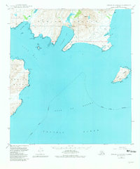
1949 Map of Kodiak B-1 and B-2
USGS Topo · Published 1981About this map
Kodiak Island shorelines meet the open waters of the Gulf of Alaska in this survey based on aerial photography from the late 1940s. The landscape is defined by the deep indentations of Pasagshak Bay and Portage Bay, where the coastal topography rises sharply to landmarks like Shaft Pk and Pyramid. Inland water bodies such as Lake Rose Tead and Lake Miam sit just behind the coastal points, illustrating the complex drainage patterns of the eastern island. Near Narrow Cape, a small Landing Strip and Barry Lagoon suggest the limited but vital infrastructure supporting this maritime environment. The presence of Ugak Island across the channel from Gull Point further emphasizes the fragmented, island-dotted nature of the Kodiak Island Borough coastline before more modern developments took root.
Find a feature on this map
27 named features on this map. Tap any name to fly to it.
Don’t see what you’re looking for? This feature index may not catch every label — zoom into the map to look around manually.
Map Details
Editions of this 1949 Kodiak B-1 and B-2 Map
4 editions found
Other maps of this area

1949 · Kodiak C-2
USGS Topo · 1:63,360

1949 · Kodiak B-1 and B-2
USGS Topo · 1:63,360

1949 · Kodiak A-3
USGS Topo · 1:63,360

1949 · Kodiak C-1
USGS Topo · 1:63,360

1949 · Kodiak B-3
USGS Topo · 1:63,360

1950 · Kodiak A-3
USGS Topo · 1:63,360

1950 · Kodiak B-3
USGS Topo · 1:63,360

1951 · Kodiak B-1 and B-2
USGS Topo · 1:63,360

1951 · Kodiak C-1
USGS Topo · 1:63,360

1952 · Kodiak
USGS Topo · 1:250,000