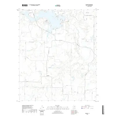
2019 Map of Kokomo
USGS Topo · Published 2019About this map
Lake Leon dominates the northern reaches of this Eastland County landscape, where the waters are fed by the Leon River and Colony Cr. Small agricultural settlements like Kokomo and Staff remain connected by a web of ranch roads and farm-to-market routes, including Ranch Rd 2214 and FM 2563. The terrain is defined by low-lying drainages like Mountain Branch and Nash Cr, punctuated by the distinctive height of Round Mtn near the lakeshore.
Find a feature on this map
73 named features on this map. Tap any name to fly to it.
Don’t see what you’re looking for? This feature index may not catch every label — zoom into the map to look around manually.
Map Details
Editions of this 2019 Kokomo Map
This is the sole edition of this map. No revisions or reprints were ever made.
Other maps of this area

1894 · Eastland
USGS Topo · 1:125,000

1954 · Abilene
USGS Topo · 1:250,000

1958 · Abilene
USGS Topo · 1:250,000

1966 · Kokomo
USGS Topo · 1:24,000
1966 · Desdemona
USGS Topo · 1:24,000

1966 · Carbon
USGS Topo · 1:24,000
1966 · Bear Mountain
USGS Topo · 1:24,000

1966 · Eastland
USGS Topo · 1:24,000

1966 · Ranger
USGS Topo · 1:24,000
1968 · Rucker
USGS Topo · 1:24,000