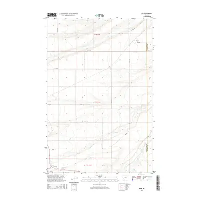
2014 Map of Kolin
USGS Topo · Published 2014About this map
Hobson and the settlement of Kolin anchor this landscape in central Montana, where the Judith Basin and Fergus County line runs north-to-south. The area is defined by the winding course of the Judith River, which receives the waters of Ross Fork Cr and Dawkins Br in the southern portion of the quadrangle. This map shows a rural environment primarily organized around a grid of agricultural roads and trails, including Whitetail Trl and Treasure Trl, which navigate the coulees and benchlands. The presence of 14N15E03CB Spring and several named creeks like Louse Cr and Olsen Cr illustrate the vital water sources that have sustained ranching and farming in this high-plains region for generations.
Find a feature on this map
31 named features on this map. Tap any name to fly to it.
Don’t see what you’re looking for? This feature index may not catch every label — zoom into the map to look around manually.
Map Details
Editions of this 2014 Kolin Map
This is the sole edition of this map. No revisions or reprints were ever made.
Other maps of this area

1889 · Big Snowy Mountain
USGS Topo · 1:250,000

1893 · Big Snowy Mountain
USGS Topo · 1:250,000

1954 · Roundup
USGS Topo · 1:250,000

1954 · Lewistown
USGS Topo · 1:250,000

1958 · Roundup
USGS Topo · 1:250,000

1959 · Lewistown
USGS Topo · 1:250,000

1970 · Harwood Bench
USGS Topo · 1:24,000

1970 · Danvers
USGS Topo · 1:24,000

1970 · Moore
USGS Topo · 1:24,000
1970 · Moccasin
USGS Topo · 1:24,000