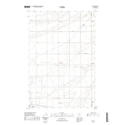
2020 Map of Kolin
USGS Topo · Published 2020About this map
Hobson stands as the primary hub in this central Montana landscape, situated at the southern edge of a vast agricultural and riparian network. The terrain is defined by the winding course of the Judith River, which carves through the Judith Basin alongside numerous tributaries including Ross Fork Cr, Olsen Cr, and Louse Cr. To the northeast, the small settlement of Kolin marks a intersection point for local routes like Kolin Rd and Sun Basin Rd. This survey documents a land organized by the Public Land Survey System, where modern county roads like Stockfarm Rd and Pioneer Rd follow section lines across the breaks and plateaus. For those studying the local geography, the map identifies specific water sources such as 14N15E05CB 01 Spring, reflecting the essential nature of water rights in this high plains environment.
Find a feature on this map
33 named features on this map. Tap any name to fly to it.
Don’t see what you’re looking for? This feature index may not catch every label — zoom into the map to look around manually.
Map Details
Editions of this 2020 Kolin Map
This is the sole edition of this map. No revisions or reprints were ever made.
Other maps of this area

1889 · Big Snowy Mountain
USGS Topo · 1:250,000

1893 · Big Snowy Mountain
USGS Topo · 1:250,000

1954 · Roundup
USGS Topo · 1:250,000

1954 · Lewistown
USGS Topo · 1:250,000

1958 · Roundup
USGS Topo · 1:250,000

1959 · Lewistown
USGS Topo · 1:250,000

1970 · Harwood Bench
USGS Topo · 1:24,000

1970 · Danvers
USGS Topo · 1:24,000

1970 · Moore
USGS Topo · 1:24,000
1970 · Moccasin
USGS Topo · 1:24,000