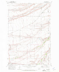
1970 Map of Kolin
USGS Topo · Published 1973About this map
The agricultural plains of Judith Basin Co and Fergus Co are bisected by the winding courses of the Judith River and Ross Fork Creek in this 1970 snapshot of central Montana. The settlement of Kolin sits along the Burlington Northern railroad line in the northern portion of the map, while Hobson occupies the southwestern corner near the confluence of several waterways.
Find a feature on this map
16 named features on this map. Tap any name to fly to it.
Don’t see what you’re looking for? This feature index may not catch every label — zoom into the map to look around manually.
Map Details
Editions of this 1970 Kolin Map
This is the sole edition of this map. No revisions or reprints were ever made.
Other maps of this area

1889 · Big Snowy Mountain
USGS Topo · 1:250,000

1893 · Big Snowy Mountain
USGS Topo · 1:250,000

1954 · Roundup
USGS Topo · 1:250,000

1954 · Lewistown
USGS Topo · 1:250,000

1958 · Roundup
USGS Topo · 1:250,000

1959 · Lewistown
USGS Topo · 1:250,000

1970 · Harwood Bench
USGS Topo · 1:24,000

1970 · Danvers
USGS Topo · 1:24,000

1970 · Moore
USGS Topo · 1:24,000
1970 · Moccasin
USGS Topo · 1:24,000