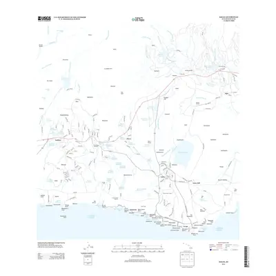
2013 Map of Koloa
USGS Topo · Published 2013About this map
The south shore of Kauai's agricultural and coastal landscape is defined here by a network of plantation-era infrastructure and burgeoning residential centers. Coastal settlements like Po'ipũ and Kukui'ula sit alongside the industrial footprint of the Koloa Mill, while the interior is dotted with numerous irrigation systems including Waita Reservoir and Alexander Reservoir. This water management network, essential for the sugar industry that historically shaped the region, feeds into the surrounding fields from sources like Omao Stream and the Lāwa'i Stream.
Find a feature on this map
230 named features on this map. Tap any name to fly to it.
Don’t see what you’re looking for? This feature index may not catch every label — zoom into the map to look around manually.
Map Details
Editions of this 2013 Koloa Map
This is the sole edition of this map. No revisions or reprints were ever made.
Other maps of this area

1954 · Kauai
USGS Topo · 1:250,000

1963 · Lihue
USGS Topo · 1:24,000

1963 · Hanapepe
USGS Topo · 1:24,000

1963 · Kapaa
USGS Topo · 1:24,000

1963 · Koloa
USGS Topo · 1:24,000

1965 · Waimea Canyon
USGS Topo · 1:24,000

1965 · Waialeale
USGS Topo · 1:24,000

1967 · Kauai
USGS Topo · 1:250,000

1970 · Kauai
USGS Topo · 1:250,000
1977 · Hanapepe
USGS Topo · 1:24,000