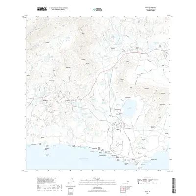
2017 Map of Koloa
USGS Topo · Published 2017About this map
The south shore of Kauai is defined here by a dense network of water management features and coastal settlements, where the terrain transitions from the high peaks of Kāhili and Kā‘ula Valley toward the Pacific. A massive system of irrigation and storage is evident through dozens of named catchments such as Alexander Reservoir, Mauka Reservoir, and Puana Reservoir, reflecting the historical infrastructure required for the region's agricultural past. Along the coast, the landscape is shaped by recreational and cultural sites, from the residential clusters at Po‘ipū and Kukui‘ula to the distinctive Nōmilo Fishpond. Inland, the map captures the transition of the land through the Knudsen Gap, where modern transit routes like Maluhia Rd connect the historic center of Kōloa with the upland communities of Kalāheo and Lāwa‘i.
Find a feature on this map
176 named features on this map. Tap any name to fly to it.
Don’t see what you’re looking for? This feature index may not catch every label — zoom into the map to look around manually.
Map Details
Editions of this 2017 Koloa Map
This is the sole edition of this map. No revisions or reprints were ever made.
Other maps of this area

1954 · Kauai
USGS Topo · 1:250,000

1963 · Lihue
USGS Topo · 1:24,000

1963 · Hanapepe
USGS Topo · 1:24,000

1963 · Kapaa
USGS Topo · 1:24,000

1963 · Koloa
USGS Topo · 1:24,000

1965 · Waimea Canyon
USGS Topo · 1:24,000

1965 · Waialeale
USGS Topo · 1:24,000

1967 · Kauai
USGS Topo · 1:250,000

1970 · Kauai
USGS Topo · 1:250,000
1977 · Hanapepe
USGS Topo · 1:24,000