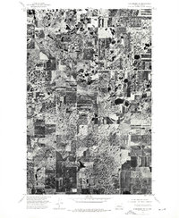
1974 Map of Kongsberg SW
USGS Topo · Published 1975About this map
Ruso stands as the primary point of settlement in this northern McLean County landscape, positioned along the railroad corridor during the mid-1970s. This orthophotoquad provides a precise visual record of the region's agricultural pattern, characterized by a dense mosaic of cultivated fields and numerous prairie potholes. The aerial perspective reveals the intricate drainage and moisture patterns typical of the North Dakota plains, showing how local farming adapted to the natural depressions and water bodies scattered across the terrain. While the infrastructure is dominated by the grid of section roads, the concentrated development at Ruso highlights its historical role as a shipping and gathering point for the surrounding rural community.
Find a feature on this map
1 named feature on this map. Tap any name to fly to it.
Don’t see what you’re looking for? This feature index may not catch every label — zoom into the map to look around manually.
Map Details
Editions of this 1974 Kongsberg SW Map
This is the sole edition of this map. No revisions or reprints were ever made.
Other maps of this area

1929 · Coleharbor
USGS Topo · 1:62,500

1929 · Benedict
USGS Topo · 1:62,500

1929 · Kongsberg
USGS Topo · 1:62,500

1947 · Turtle Lake
USGS Topo · 1:62,500

1954 · McClusky
USGS Topo · 1:250,000

1958 · McClusky
USGS Topo · 1:250,000
1958 · Kongsberg NE
USGS Topo · 1:24,000

1974 · Benedict SE
USGS Topo · 1:24,000
1974 · Kongsberg NW
USGS Topo · 1:24,000
1974 · Benedict NE
USGS Topo · 1:24,000