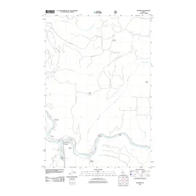
2011 Map of Kooskia
USGS Topo · Published 2011About this map
Kooskia sits at the dramatic confluence where the South Fork Clearwater River and the Middle Fork Clearwater River join to form the main stem of the Clearwater River. This 2011 survey documents the valley's complex road network, including steep mountain routes like Adams Grade and Winona Grade Rd, which negotiate the elevation gains of Kidder Ridge and Harris Ridge. The map detail reveals a landscape defined by water and infrastructure, from the Kooskia National Fish Hatchery along Clear Creek to the Kooskia Municipal Airport south of town. Genealogists can locate several burial sites throughout the rugged terrain, including Miller Cemetery, Nicodemus Cemetery, and Grandview Cemetery near the settlement of Kidder. Notable river features such as Maggie Bend and the Penny Cliffs highlight the winding course of the Middle Fork as it cuts through the Idaho wilderness.
Find a feature on this map
33 named features on this map. Tap any name to fly to it.
Don’t see what you’re looking for? This feature index may not catch every label — zoom into the map to look around manually.
Map Details
Editions of this 2011 Kooskia Map
This is the sole edition of this map. No revisions or reprints were ever made.
Other maps of this area

1924 · Kamiah
USGS Topo · 1:125,000

1924 · Weippe
USGS Topo · 1:125,000

1955 · Pullman
USGS Topo · 1:250,000

1956 · Hamilton
USGS Topo · 1:250,000

1958 · Pullman
USGS Topo · 1:250,000

1959 · Hamilton
USGS Topo · 1:250,000

1960 · Hamilton
USGS Topo · 1:250,000

1964 · Hamilton
USGS Topo · 1:250,000

1966 · Kooskia
USGS Topo · 1:24,000
1966 · Stites
USGS Topo · 1:24,000