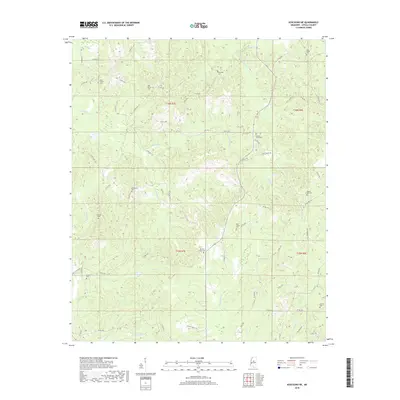
2018 Map of Kosciusko NE
USGS Topo · Published 2018About this map
Pierces Chapel Cem sits at the heart of this Attala County landscape, surrounded by a complex network of rural routes including Shady Grove Rd and Old Trace Rd. The terrain is defined by its many small watercourses, such as Zilpha Cr and Scoobachita Cr, which carve through the countryside. This area is notable for its dense concentration of burial grounds, many associated with small communities or family plots, such as New Salem Cem, Oak Grove Cem, and Smyrna Cem. These sites, along with others like Holy Grove Cem and Pilgrim Rest Cem, provide essential anchor points for genealogical research in this part of Mississippi. The road network, primarily composed of numbered county roads like Co RD 3226 and Co RD 2225, connects these scattered landmarks across the drainage basins of Hurricane Cr and Sugar Cr.
Find a feature on this map
60 named features on this map. Tap any name to fly to it.
Don’t see what you’re looking for? This feature index may not catch every label — zoom into the map to look around manually.
Map Details
Editions of this 2018 Kosciusko NE Map
This is the sole edition of this map. No revisions or reprints were ever made.
Other maps of this area

1953 · West Point
USGS Topo · 1:250,000

1958 · West Point
USGS Topo · 1:250,000

1963 · West Point
USGS Topo · 1:250,000

1964 · Kosciusko NE
USGS Topo · 1:24,000

1964 · Hesterville
USGS Topo · 1:24,000

1964 · Kosciusko
USGS Topo · 1:24,000
1964 · McAdams
USGS Topo · 1:24,000

1966 · Poplar Creek
USGS Topo · 1:24,000

1966 · Kosciusko
USGS Topo · 1:62,500

1966 · French Camp
USGS Topo · 1:24,000