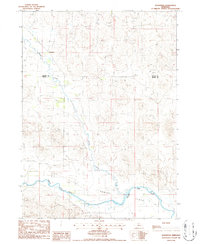
1986 Map of Koshopah
USGS Topo · Published 1986About this map
Goose Creek flows southward through the Sandhills of north-central Nebraska, joining the North Loup River in a landscape defined by expansive ranching territory and sparse human settlement. The small community of Koshopah stands near the northern reaches of the creek, serving as a focal point for the surrounding rural area at the boundary of Brown and Blaine counties. The terrain is characterized by stabilized dunes and broad alluvial basins, most notably the Hawley Flats south of the river. Evidence of local land use is visible in the network of 4wd trails that cross the dunes, connecting remote ranch sites and water features like the isolated Well near the center of the sheet. A small Cem (cemetery) in the northeastern corner provides a point of interest for genealogists tracing early families in this thinly populated portion of the Nebraska interior.
Find a feature on this map
53 named features on this map. Tap any name to fly to it.
Don’t see what you’re looking for? This feature index may not catch every label — zoom into the map to look around manually.
Map Details
Editions of this 1986 Koshopah Map
This is the sole edition of this map. No revisions or reprints were ever made.
Other maps of this area

1949 · Koshopah
USGS Topo · 1:62,500

1951 · Dunning
USGS Topo · 1:62,500

1951 · Koshopah
USGS Topo · 1:62,500

1952 · Brewster NW
USGS Topo · 1:24,000

1954 · North Platte
USGS Topo · 1:250,000

1955 · Broken Bow
USGS Topo · 1:250,000

1955 · O'Neill
USGS Topo · 1:250,000

1956 · Broken Bow
USGS Topo · 1:250,000

1956 · North Platte
USGS Topo · 1:250,000

1957 · North Platte
USGS Topo · 1:250,000