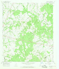
1966 Map of Kosse East
USGS Topo · Published 1969About this map
The town of Kosse serves as the focal point for this mid-1960s landscape, situated where the Southern Pacific tracks cut through the western portion of the Limestone and Robertson County line. This area is characterized by a high density of rural cemeteries and small community churches, many of which appear as isolated landmarks in an agricultural and industrial countryside. Researchers can locate Eutaw Cem and the nearby Eutaw Ch, alongside family-named sites like Sowders Cem and Buttrill Cem.
Find a feature on this map
38 named features on this map. Tap any name to fly to it.
Don’t see what you’re looking for? This feature index may not catch every label — zoom into the map to look around manually.
Map Details
Editions of this 1966 Kosse East Map
2 editions found
Other maps of this area

1927 · Marquez
USGS Topo · 1:62,500

1930 · Marquez
USGS Topo · 1:62,500

1954 · Waco
USGS Topo · 1:250,000

1955 · Waco
USGS Topo · 1:250,000

1962 · Bremond
USGS Topo · 1:24,000

1962 · Petteway
USGS Topo · 1:24,000
1965 · Bald Prairie
USGS Topo · 1:24,000

1965 · Kosse West
USGS Topo · 1:24,000

1966 · Thornton
USGS Topo · 1:24,000
1966 · Box Church
USGS Topo · 1:24,000