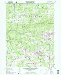
1963 Map of Kossuth
USGS Topo · Published 1973About this map
Oil and gas wells dot the Pennsylvania countryside in this early 1960s survey, marking a landscape defined by natural resource extraction and rural crossroads. The area around Kossuth and Nineveh serves as a hub for local life, with several country churches like St Marks Ch and Grace Ch anchoring the community. The topography is deeply carved by the waters of East Sandy Creek and its many tributaries, including Prairie Run and Cogley Run, which separate the various townships of Ashland and Elk.
Find a feature on this map
46 named features on this map. Tap any name to fly to it.
Don’t see what you’re looking for? This feature index may not catch every label — zoom into the map to look around manually.
Map Details
Editions of this 1963 Kossuth Map
3 editions found
Other maps of this area

1906 · Clarion
USGS Topo · 1:62,500

1907 · Clarion
USGS Topo · 1:62,500

1907 · Foxburg
USGS Topo · 1:62,500

1908 · Foxburg
USGS Topo · 1:62,500

1922 · Oil City
USGS Topo · 1:48,000

1922 · Tionesta
USGS Topo · 1:62,500

1924 · Oil City
USGS Topo · 1:62,500

1924 · Tionesta
USGS Topo · 1:62,500

1943 · Oil City
USGS Topo · 1:62,500

1946 · Tionesta
USGS Topo · 1:62,500
Featured Places
- Cranberry Township, PA
- Rockland Township, PA
- Powell Corners, Pinegrove Township
- Ashland Township, PA
- Richland Township, PA