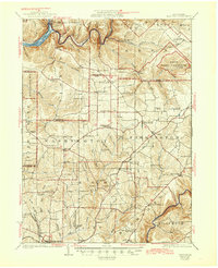
1924 Map of Tionesta
USGS Topo · Published 1944About this map
The Allegheny River and Clarion River define the north and south bounds of this landscape, which spans the border of Forest, Venango, and Clarion counties. A dense network of rural one-room schoolhouses, such as Rattlesnake School and Love School, marks the township structure in the early 1920s. In the north, the Allegheny National Forest and a State Game Preserve occupy the wooded highlands between Tionesta Creek and Coon Creek.
Find a feature on this map
92 named features on this map. Tap any name to fly to it.
Don’t see what you’re looking for? This feature index may not catch every label — zoom into the map to look around manually.
Map Details
Editions of this 1924 Tionesta Map
4 editions found
Other maps of this area

1906 · Clarion
USGS Topo · 1:62,500

1907 · Clarion
USGS Topo · 1:62,500

1907 · Foxburg
USGS Topo · 1:62,500

1908 · Foxburg
USGS Topo · 1:62,500

1918 · Loleta
USGS Topo · 1:62,500

1922 · Oil City
USGS Topo · 1:48,000

1922 · Tionesta
USGS Topo · 1:62,500

1924 · Oil City
USGS Topo · 1:62,500

1924 · Tionesta
USGS Topo · 1:62,500

1924 · Brookville
USGS Topo · 1:62,500