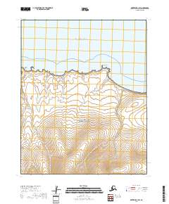
2018 Map of Kotzebue A-3 SW
USGS Topo · Published 2018About this map
Kotzebue Sound defines the northern edge of this coastal landscape, where the tides meet a series of prominent geographical markers along the shoreline. Much of the southern portion of the area is protected within the Bering Land Bridge National Preserve, reflecting a wilderness preserved for its geological and cultural significance. The coastline itself is punctuated by Clifford Point and Rex Point, which serve as natural anchors for the small drainage systems that flow into the sound. Inland, the terrain is shaped by the paths of Clifford Cr, Reindeer Cr, and Rex Cr, which cut through the tundra. The mapping of the public land survey system lines, including t8n r23w and t7n r22w, illustrates the systematic grid overlaying this remote corner of the Northwest Arctic Borough.
Find a feature on this map
11 named features on this map. Tap any name to fly to it.
Don’t see what you’re looking for? This feature index may not catch every label — zoom into the map to look around manually.
Map Details
Editions of this 2018 Kotzebue A-3 SW Map
This is the sole edition of this map. No revisions or reprints were ever made.
Other maps of this area

1950 · Bendeleben
USGS Topo · 1:250,000

1950 · Bendeleben D-3
USGS Topo · 1:63,360

1950 · Bendeleben D-4
USGS Topo · 1:63,360

1950 · Kotzebue A-4
USGS Topo · 1:63,360

1950 · Kotzebue A-3
USGS Topo · 1:63,360

1951 · Bendeleben
USGS Topo · 1:250,000

1951 · Kotzebue
USGS Topo · 1:250,000

1958 · Kotzebue
USGS Topo · 1:250,000

1964 · Bendeleben
USGS Topo · 1:250,000

1964 · Kotzebue
USGS Topo · 1:250,000