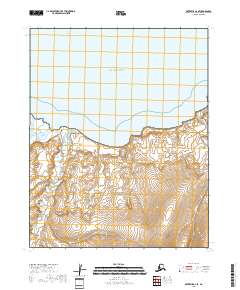
2018 Map of Kotzebue A-4 SE
USGS Topo · Published 2018About this map
Bering Land Bridge National Preserve occupies the southern half of this coastal landscape, protecting a vast stretch of Arctic tundra and wetlands. Along the shoreline, the waters of Kotzebue Sound meet the northern coast, forming the wide indentation of Goodhope Bay. Several significant waterways drain northward into this bay, including the Goodhope River and the Cripple River. The terrain is characterized by intricate drainage patterns and numerous small ponds across the low-lying coastal plain, while smaller tributaries like Francis Cr and Clifford Cr carve through the southern uplands. This area represents a critical intersection of marine and terrestrial ecosystems on the Seward Peninsula, captured here as it remained largely undeveloped in the early twenty-first century.
Find a feature on this map
11 named features on this map. Tap any name to fly to it.
Don’t see what you’re looking for? This feature index may not catch every label — zoom into the map to look around manually.
Map Details
Editions of this 2018 Kotzebue A-4 SE Map
This is the sole edition of this map. No revisions or reprints were ever made.
Other maps of this area

1950 · Bendeleben
USGS Topo · 1:250,000

1950 · Bendeleben D-3
USGS Topo · 1:63,360

1950 · Bendeleben D-4
USGS Topo · 1:63,360

1950 · Kotzebue A-4
USGS Topo · 1:63,360

1950 · Kotzebue A-3
USGS Topo · 1:63,360

1951 · Bendeleben
USGS Topo · 1:250,000

1951 · Kotzebue
USGS Topo · 1:250,000

1958 · Kotzebue
USGS Topo · 1:250,000

1964 · Bendeleben
USGS Topo · 1:250,000

1964 · Kotzebue
USGS Topo · 1:250,000