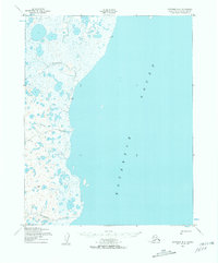
1950 Map of Kotzebue B-4
USGS Topo · Published 1957About this map
The coastal wetlands and tundra of Northwest Arctic, Alaska, define this mid-century survey, centered on the eastern reach of Kotzebue Sound. The landscape is characterized by a dense network of unnamed lakes and lagoons that separate the marine environment from the interior. A notable human element in this remote terrain is the Winter Trail (Approximate), which cuts westward across the marshland toward the coast, illustrating the seasonal transportation methods required in the Arctic. To the south, Kougachuk Creek winds through the low-lying plain, while further north, the distinct branches of Kungealoruk Creek drain into the sound. This map, based on aerial photography from 1949 and 1950, documents the hydrology of the Baldwin Peninsula area before significant modern changes.
Find a feature on this map
5 named features on this map. Tap any name to fly to it.
Don’t see what you’re looking for? This feature index may not catch every label — zoom into the map to look around manually.
Map Details
Editions of this 1950 Kotzebue B-4 Map
2 editions found
Other maps of this area
1950 · Kotzebue C-5
USGS Topo · 1:63,360

1950 · Kotzebue B-4
USGS Topo · 1:63,360

1950 · Kotzebue B-5
USGS Topo · 1:63,360
1950 · Kotzebue C-4
USGS Topo · 1:63,360

1950 · Kotzebue A-4
USGS Topo · 1:63,360

1950 · Kotzebue A-5
USGS Topo · 1:63,360

1950 · Kotzebue A-3
USGS Topo · 1:63,360

1951 · Kotzebue
USGS Topo · 1:250,000

1958 · Kotzebue
USGS Topo · 1:250,000

1964 · Kotzebue
USGS Topo · 1:250,000