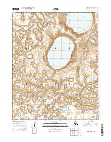
2014 Map of Kotzebue B-5 SE
USGS Topo · Published 2014About this map
Bering Land Bridge National Preserve contains a dramatic expanse of volcanic and arctic terrain within the Seward Peninsula region. This 2014 survey focuses on the landscape surrounding the large, water-filled craters of the Killeak Lakes, which are significant geological features of the area. The hydrology is further defined by the winding course of Kougachuk Cr as it traverses the tundra. The lack of man-made infrastructure or settlements on this sheet highlights the protected status of the preserve, offering a clear record of the undisturbed drainage patterns and the specific elevations of the volcanic lake rims as they were measured in the early 21st century.
Find a feature on this map
7 named features on this map. Tap any name to fly to it.
Don’t see what you’re looking for? This feature index may not catch every label — zoom into the map to look around manually.
Map Details
Editions of this 2014 Kotzebue B-5 SE Map
This is the sole edition of this map. No revisions or reprints were ever made.
Other maps of this area

1950 · Kotzebue B-4
USGS Topo · 1:63,360

1950 · Kotzebue B-5
USGS Topo · 1:63,360

1950 · Kotzebue A-4
USGS Topo · 1:63,360

1950 · Kotzebue A-5
USGS Topo · 1:63,360

1951 · Kotzebue
USGS Topo · 1:250,000

1958 · Kotzebue
USGS Topo · 1:250,000

1964 · Kotzebue
USGS Topo · 1:250,000
2014 · Kotzebue A-5 NE
USGS Topo · 1:25,000
2014 · Kotzebue B-5 SW
USGS Topo · 1:25,000
2014 · Kotzebue A-4 NW
USGS Topo · 1:25,000