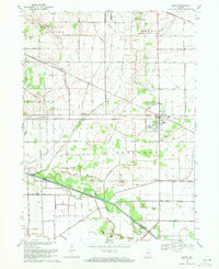
1969 Map of Kouts
USGS Topo · Published 1971About this map
Kouts serves as the central hub of this Indiana landscape, situated at the busy intersection of the Erie-Lackawanna and Penn Central railroads. The town's layout is meticulously detailed, including local landmarks like the Radio Tower and proximity to Graceland and Spencer cemeteries. The surrounding terrain in Boone and Pleasant townships is defined by an extensive network of drainage infrastructure, such as Cobb Ditch and Sandy Hook Ditch, which redirect water through the lowlands toward the Kankakee River. This complex system of ditches and spoil banks, including Spoil Bank Ditch, illustrates the intensive mid-century engineering required to maintain the agricultural productivity of the Kankakee valley. Smaller settlements like Aylesworth and Five Points Corner appear along the regional road grid, while the southern border tracks the winding course of the river at the Porter and Jasper county line.
Find a feature on this map
30 named features on this map. Tap any name to fly to it.
Don’t see what you’re looking for? This feature index may not catch every label — zoom into the map to look around manually.
Map Details
Editions of this 1969 Kouts Map
2 editions found
Other maps of this area

1953 · Palmer
USGS Topo · 1:24,000

1953 · Wanatah
USGS Topo · 1:24,000

1953 · Hebron
USGS Topo · 1:24,000

1953 · Valparaiso
USGS Topo · 1:24,000

1953 · Kouts
USGS Topo · 1:24,000

1953 · Chicago
USGS Topo · 1:250,000

1957 · Chicago
USGS Topo · 1:250,000

1957 · Wheatfield
USGS Topo · 1:24,000

1957 · DeMotte
USGS Topo · 1:24,000

1958 · La Crosse
USGS Topo · 1:24,000