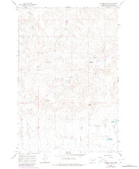
1965 Map of Kramer Ranch
USGS Topo · Published 1980About this map
Kramer Ranch anchors the northwest corner of this Garfield County landscape, where the high plains are carved by a complex network of intermittent drainages. The map reveals a land defined by water management and natural springs, vital for survival and ranching in this part of Montana. Named watering points such as Lemon Spring, Birkrem Spring, and Acorn Spring indicate the critical importance of localized water sources. The presence of numbered catchments like Ten Reservoir and Fourteen Reservoir further reflects the systematic modification of the drainage basins, including West Fork Basin Creek and Little Dry Creek. Landforms like Blazier Butte provide distinct navigational landmarks above the coulees, while the survey includes family-named features like Birkrem Reservoir and Yoakum Spring, which offer specific points of interest for local history and genealogy research.
Find a feature on this map
16 named features on this map. Tap any name to fly to it.
Don’t see what you’re looking for? This feature index may not catch every label — zoom into the map to look around manually.
Map Details
Editions of this 1965 Kramer Ranch Map
2 editions found
Other maps of this area

1954 · Jordan
USGS Topo · 1:250,000

1954 · Forsyth
USGS Topo · 1:250,000

1956 · Jordan
USGS Topo · 1:250,000

1957 · Forsyth
USGS Topo · 1:250,000

1958 · Jordan
USGS Topo · 1:250,000

1958 · Forsyth
USGS Topo · 1:250,000

1964 · Jordan
USGS Topo · 1:250,000

1965 · Acorn Flats
USGS Topo · 1:24,000

1965 · Kramer Ranch
USGS Topo · 1:24,000

1965 · Hole-In-The-Rock
USGS Topo · 1:24,000