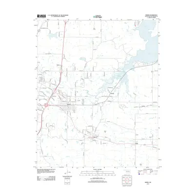
2012 Map of Krebs
USGS Topo · Published 2012About this map
Krebs and its surrounding coal-mining heritage settlements define this portion of Pittsburg County just east of McAlester. This 2012 survey reveals the residential expansion and modern road networks connecting established communities like Alderson, Bache, and Richville. The northeastern quadrant is dominated by the sprawling reaches of Eufaula Lake, where the shoreline meets low-lying terrain drained by Fish Cr and Buck Cr. For genealogists, the map is a vital resource, identifying several distinct burial grounds including High Hill Cem, Carbon Cem, and Calvary Cem. Local landmarks such as Pine Knob and Buck Hill provide vertical relief in an area otherwise characterized by a mix of suburban development and creek-side wetlands. The grid-like layout of Carbon and the established streets of Memory Gardens illustrate the continued importance of these towns within the regional landscape.
Find a feature on this map
125 named features on this map. Tap any name to fly to it.
Don’t see what you’re looking for? This feature index may not catch every label — zoom into the map to look around manually.
Map Details
Editions of this 2012 Krebs Map
This is the sole edition of this map. No revisions or reprints were ever made.
Other maps of this area

1898 · McAlester
USGS Topo · 1:125,000

1900 · Canadian
USGS Topo · 1:125,000

1909 · Mc Alester
USGS Topo · 1:125,000

1946 · Fort Smith
USGS Topo · 1:250,000

1950 · Mcalester
USGS Topo · 1:250,000

1962 · McAlester
USGS Topo · 1:250,000

1965 · Fort Smith
USGS Topo · 1:250,000

1965 · McAlester
USGS Topo · 1:250,000

1967 · Fort Smith
USGS Topo · 1:250,000

1967 · Krebs
USGS Topo · 1:24,000