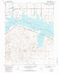
1953 Map of Kreybill
USGS Topo · Published 1985About this map
John Martin Reservoir dominates this high-plains landscape in Bent County, where the 1953 topography meets 1970s updates. The map preserves the geography of westward expansion through markers for Old Fort Lyon and Fort Bent, alongside the Old Santa Fe Trail. Settlement patterns are centered around the Atchison Topeka and Santa Fe railroad, which runs south of the reservoir through Hilton. Further north, the small community of Kreybill is identified by the Kreybill Sch, surrounded by a network of agricultural infrastructure including the Kicking Bird Canal and various irrigation ditches. This survey documents a critical intersection of historical trail routes, mid-century rail transit, and the hydraulic engineering of the Fort Lyon Canal system used to manage the arid Colorado terrain.
Find a feature on this map
22 named features on this map. Tap any name to fly to it.
Don’t see what you’re looking for? This feature index may not catch every label — zoom into the map to look around manually.
Map Details
Editions of this 1953 Kreybill Map
4 editions found
Other maps of this area

1891 · Higbee
USGS Topo · 1:125,000

1891 · Las Animas
USGS Topo · 1:125,000

1892 · Lamar
USGS Topo · 1:125,000

1892 · Two Butte
USGS Topo · 1:125,000

1893 · Higbee
USGS Topo · 1:125,000

1893 · Two Butte
USGS Topo · 1:125,000

1893 · Las Animas
USGS Topo · 1:125,000

1953 · Hasty
USGS Topo · 1:24,000

1953 · Las Animas
USGS Topo · 1:24,000

1953 · Kreybill
USGS Topo · 1:24,000