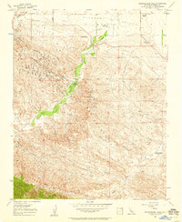
1956 Map of Kreyenhagen Hills
USGS Topo · Published 1958About this map
Coalinga Oil Field dominates the northwest corner of this mid-century survey, where a network of Oil Wells, Oil Tanks, and Oil Sump sites reveal the industrial character of the Fresno County landscape. The terrain transitions from the relatively level Pleasant Valley into the dissected uplands of the Jacalitos Hills and Kreyenhagen Hills. This area is defined by its ranching history, with numerous established family holdings such as the Kreyenhagen Ranch, Van Dyke Ranch, and Johnson Ranch situated along the seasonal drainages. Water management is critical in this arid environment, evidenced by the scattered Grain Tank and Water Tank labels and the winding courses of Jacalitos Creek and Warthan Creek. The presence of several Gas Wells alongside the petroleum infrastructure underscores the diverse energy extraction activities that shaped the local economy during this era.
Find a feature on this map
30 named features on this map. Tap any name to fly to it.
Don’t see what you’re looking for? This feature index may not catch every label — zoom into the map to look around manually.
Map Details
Editions of this 1956 Kreyenhagen Hills Map
3 editions found
Other maps of this area

1912 · Coalinga
USGS Topo · 1:125,000

1914 · Cholame
USGS Topo · 1:125,000

1915 · Cholame
USGS Topo · 1:125,000

1917 · Cholame
USGS Topo · 1:125,000

1930 · Canoas Creek
USGS Topo · 1:31,680

1933 · Guijarral Hills
USGS Topo · 1:31,680

1934 · The Dark Hole
USGS Topo · 1:31,680

1934 · Reef Ridge
USGS Topo · 1:31,680

1934 · Canoas Creek
USGS Topo · 1:31,680

1936 · Kreyenhagen Hills
USGS Topo · 1:31,680