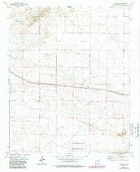
1973 Map of Krider
USGS Topo · Published 1987About this map
The Atchison Topeka and Santa Fe railroad corridor defines the central activity of this Roosevelt County landscape, connecting the small rail sidings of Krider and Cantara. This 1973 survey, with photorevisions through the mid-1980s, captures a transition from traditional ranching features like the Dobie Windmill and scattered Well sites to specialized land use in the southern portion of the quadrangle. A significant section of the Melrose Bombing Range occupies the south, defined by a clear Military Reservation Boundary. The terrain is characterized by the drainage of Alamosa Creek in the northwest and natural Sand Dunes to the southeast, while the presence of several Drill Hole locations and a Gravel Pit suggests localized resource extraction alongside the long-established rail infrastructure and rugged Jeep Trail networks.
Find a feature on this map
18 named features on this map. Tap any name to fly to it.
Don’t see what you’re looking for? This feature index may not catch every label — zoom into the map to look around manually.
Map Details
Editions of this 1973 Krider Map
2 editions found
Other maps of this area

1954 · Clovis
USGS Topo · 1:250,000

1957 · Melrose
USGS Topo · 1:62,500

1958 · Clovis
USGS Topo · 1:250,000

1973 · Tolar
USGS Topo · 1:24,000

1973 · Krider
USGS Topo · 1:24,000

1973 · Melrose West
USGS Topo · 1:24,000

1973 · Tule Lake
USGS Topo · 1:24,000
1973 · Peach Canyon
USGS Topo · 1:24,000

1973 · Field SW
USGS Topo · 1:24,000
1973 · House SE
USGS Topo · 1:24,000