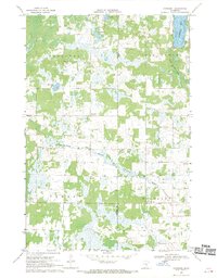
1968 Map of Kroschel
USGS Topo · Published 1970About this map
The boundary between Kanabec and Pine counties divides this landscape of glacial lakes and wetlands during the late 1960s. The rural settlement of Kroschel and the nearby Townhall serve as the primary hubs for a scattered community of farmsteads. Local spiritual and genealogical life is anchored by St John Ch and the Trinity Cem located near the northern edge. Water management is a defining feature of the terrain, evident in the engineered Judicial Ditch No 10 and the natural flow of the North Branch Grindstone River and South Branch Grindstone River. Named water bodies such as Grindstone Lake, Thirteen Lake, and White Lily Lake dot the wooded parcels, while several Gravel Pits indicate local resource extraction in Hinckley and Pomroy townships. The map captures a transition point where traditional timber and farming land meets the systematic drainage efforts of the mid-20th century.
Find a feature on this map
18 named features on this map. Tap any name to fly to it.
Don’t see what you’re looking for? This feature index may not catch every label — zoom into the map to look around manually.
Map Details
Editions of this 1968 Kroschel Map
This is the sole edition of this map. No revisions or reprints were ever made.
Other maps of this area

1953 · Duluth
USGS Topo · 1:250,000

1953 · Stillwater
USGS Topo · 1:250,000

1955 · Stillwater
USGS Topo · 1:250,000

1958 · Stillwater
USGS Topo · 1:250,000

1958 · Duluth
USGS Topo · 1:250,000

1961 · Sandstone
USGS Topo · 1:62,500

1961 · Brook Park
USGS Topo · 1:62,500

1961 · Pine City
USGS Topo · 1:62,500

1965 · Stillwater
USGS Topo · 1:250,000

1968 · Kroschel NW
USGS Topo · 1:24,000