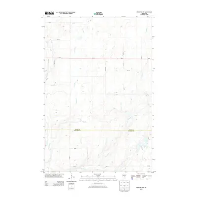
2013 Map of Kroschel NW
USGS Topo · Published 2013About this map
The Snake River winds through the western edge of this rural landscape, carving a path through the borderlands of northern Kanabec and southern Aitkin Counties. In the early 21st century, this area remains characterized by its complex hydrology, with the meandering courses of Cowans Brook and Chelsey Brook feeding into the river system. To the southeast, small water bodies like Long Lake and Lake Five punctuate the terrain, connected by a network of local routes such as Aleta Trl and Spruce St. The placement of the Aitkin and Kanabec County line provides a clear marker for boundary researchers and genealogists tracing property records in this portion of Ford Township. This survey illustrates a quiet transition from wooded wetlands to dispersed rural road networks like Silver Star Rd and Waylen Rd that facilitate movement between the scattered homesteads of the region.
Find a feature on this map
28 named features on this map. Tap any name to fly to it.
Don’t see what you’re looking for? This feature index may not catch every label — zoom into the map to look around manually.
Map Details
Editions of this 2013 Kroschel NW Map
This is the sole edition of this map. No revisions or reprints were ever made.
Other maps of this area

1953 · Duluth
USGS Topo · 1:250,000

1958 · Duluth
USGS Topo · 1:250,000

1968 · Kroschel NW
USGS Topo · 1:24,000

1968 · Pomroy Lake
USGS Topo · 1:24,000

1968 · Warman
USGS Topo · 1:24,000

1968 · Giese
USGS Topo · 1:24,000
1968 · Kroschel
USGS Topo · 1:24,000

1968 · Mc Grath
USGS Topo · 1:24,000

1969 · Solana
USGS Topo · 1:24,000

1969 · Arthyde
USGS Topo · 1:24,000