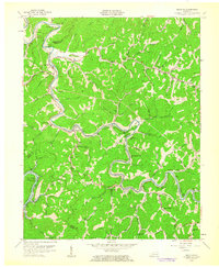
1961 Map of Krypton
USGS Topo · Published 1962About this map
The North Fork Kentucky River snakes through the heart of Perry County, dictating the development of the mountain landscape. Following the river's winding path, the Louisville and Nashville Railroad serves as the primary transportation artery for small coal-country settlements like Krypton and Chavies. The map reveals a high density of rural institutions, such as Napfor Sch and Old Campbell Bend Ch, which supported isolated communities living in the narrow hollows. Significant engineering is evident where the rail line cuts through the terrain at Yerkes Tunnel and Campbell Tunnel. Numerous labels for Mine pepper the hillsides, reflecting the extractive economy that shaped this region in the early 1960s. The presence of the Buckhorn Reservoir at the western edge indicates the beginning of modern water management and recreation in this part of the Cumberland Plateau.
Find a feature on this map
81 named features on this map. Tap any name to fly to it.
Don’t see what you’re looking for? This feature index may not catch every label — zoom into the map to look around manually.
Map Details
Editions of this 1961 Krypton Map
This is the sole edition of this map. No revisions or reprints were ever made.
Other maps of this area

1891 · Hazard
USGS Topo · 1:125,000

1913 · Buckhorn
USGS Topo · 1:62,500

1914 · Troublesome
USGS Topo · 1:62,500

1916 · Cornettsville
USGS Topo · 1:62,500

1916 · Hyden
USGS Topo · 1:48,000

1919 · Hyden
USGS Topo · 1:62,500

1953 · Buckhorn
USGS Topo · 1:24,000

1953 · Hyden West
USGS Topo · 1:24,000

1954 · Noble
USGS Topo · 1:24,000

1954 · Krypton
USGS Topo · 1:24,000