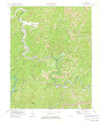
1972 Map of Krypton
USGS Topo · Published 1973About this map
The North Fork Kentucky River snakes through the dense, dissection-heavy topography of Perry County, serving as the central artery for a series of mountain settlements connected by the Louisville & Nashville railroad. The community of Krypton sits along this river corridor, while nearby Chavies serves as a local hub with its own Chavies Sch. The landscape is defined by its deep hollows and narrow ridges, such as Oldhouse Ridge, where dozens of named branches like Pigeonroost Creek and Rockhouse Fork drain into the primary river valley.
Find a feature on this map
67 named features on this map. Tap any name to fly to it.
Don’t see what you’re looking for? This feature index may not catch every label — zoom into the map to look around manually.
Map Details
Editions of this 1972 Krypton Map
This is the sole edition of this map. No revisions or reprints were ever made.
Other maps of this area

1891 · Hazard
USGS Topo · 1:125,000

1913 · Buckhorn
USGS Topo · 1:62,500

1914 · Troublesome
USGS Topo · 1:62,500

1916 · Cornettsville
USGS Topo · 1:62,500

1916 · Hyden
USGS Topo · 1:48,000

1919 · Hyden
USGS Topo · 1:62,500

1953 · Buckhorn
USGS Topo · 1:24,000

1953 · Hyden West
USGS Topo · 1:24,000

1954 · Noble
USGS Topo · 1:24,000

1954 · Krypton
USGS Topo · 1:24,000