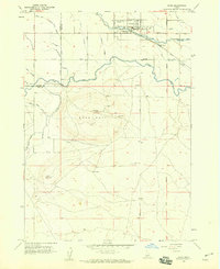
1958 Map of Kuna
USGS Topo · Published 1959About this map
The town of Kuna serves as the focal point for this late 1950s survey of southern Ada County, where the desert landscape meets a sophisticated network of early irrigation engineering. The Union Pacific and Oregon Short Line Railroad cut through the northern half of the sheet, paralleling the course of Indian Creek. The map reveals a transition from the agricultural grid supported by the New York Canal and Mora Canal to the distinctive volcanic topography of the south. Kuna Butte dominates the central terrain, while the subterranean Kuna Cave and local Cinder Pit operations highlight the area's geological character. This record captures the precise infrastructure of rural Idaho life, from the Mc Clenagan Siphon and numerous water laterals to the small community Cem and local Water Tank that anchored the town site.
Find a feature on this map
33 named features on this map. Tap any name to fly to it.
Don’t see what you’re looking for? This feature index may not catch every label — zoom into the map to look around manually.
Map Details
Editions of this 1958 Kuna Map
3 editions found
Other maps of this area

1892 · Boise
USGS Topo · 1:125,000

1892 · Bisuka
USGS Topo · 1:125,000

1892 · Silver City
USGS Topo · 1:125,000

1894 · Bisuka
USGS Topo · 1:125,000

1894 · Silver City
USGS Topo · 1:125,000

1897 · Boise
USGS Topo · 1:125,000

1898 · Nampa
USGS Topo · 1:125,000

1898 · Silver City
USGS Topo · 1:125,000

1953 · Cloverdale
USGS Topo · 1:24,000

1953 · Meridian
USGS Topo · 1:24,000