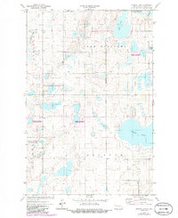
1972 Map of Kunkel Lake
USGS Topo · Published 1986About this map
Kunkel Lake and the surrounding wetland complex dominate this part of Kidder County, illustrating a landscape defined by prairie potholes and conservation efforts. During the early 1970s, much of the area was designated as a National Waterfowl Production Area, reflecting the region's importance for migratory birds and local wildlife management. The map details a sparsely populated rural district where township lines like Robinson, Lake Williams, and Buckeye meet among numerous water bodies including Sink Lake, Iowa Lake, and South Lake. Scattered human footprints are captured through small-scale landmarks such as a remote Cem, an isolated Grave, and a Landing Field positioned near the lake's eastern shore, providing specific points of interest for genealogists and local historians researching these North Dakota townships.
Find a feature on this map
13 named features on this map. Tap any name to fly to it.
Don’t see what you’re looking for? This feature index may not catch every label — zoom into the map to look around manually.
Map Details
Editions of this 1972 Kunkel Lake Map
2 editions found
Other maps of this area

1952 · Tappen NE
USGS Topo · 1:24,000

1952 · Tappen North
USGS Topo · 1:24,000

1952 · Steele NE
USGS Topo · 1:24,000

1952 · New Rockford
USGS Topo · 1:250,000

1953 · Jamestown
USGS Topo · 1:250,000

1956 · New Rockford
USGS Topo · 1:250,000

1956 · Jamestown
USGS Topo · 1:250,000

1971 · New Rockford
USGS Topo · 1:250,000

1972 · Kunkel Lake
USGS Topo · 1:24,000
1972 · Horsehead Lake
USGS Topo · 1:24,000