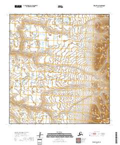
2018 Map of Kwiguk D-2 NW
USGS Topo · Published 2018About this map
Pastoliak River winds through the southwestern reaches of this terrain, a vital watercourse in the Kusilvak Census Area. The landscape is defined by an intricate network of wetlands and tundra, reflecting the hydrology as documented by the National Hydrography Dataset through 2015. This survey illustrates the Public Land Survey System divisions, including boundaries for t34n r72w, t33n r72w, and t32n r72w, which provide the legal framework for this remote Alaskan territory. The eastern portion of the map shows a marked shift in elevation with concentrated contour lines, contrasting sharply with the vast, low-lying marshlands to the west.
Find a feature on this map
8 named features on this map. Tap any name to fly to it.
Don’t see what you’re looking for? This feature index may not catch every label — zoom into the map to look around manually.
Map Details
Editions of this 2018 Kwiguk D-2 NW Map
This is the sole edition of this map. No revisions or reprints were ever made.
Other maps of this area

1951 · St Michael
USGS Topo · 1:250,000

1952 · Kwiguk
USGS Topo · 1:250,000

1952 · Kwiguk D-2
USGS Topo · 1:63,360

1952 · Kwiguk D-3
USGS Topo · 1:63,360
1952 · Saint Michael A-3
USGS Topo · 1:63,360

1952 · Saint Michael A-2
USGS Topo · 1:63,360

1952 · St Michael
USGS Topo · 1:250,000

1964 · St. Michael
USGS Topo · 1:250,000
2017 · Saint Michael A-2 SW
USGS Topo · 1:25,000
2017 · Saint Michael A-2 SE
USGS Topo · 1:25,000