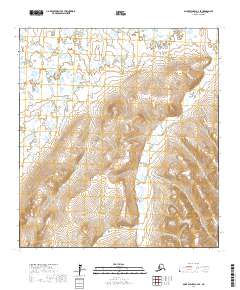
2017 Map of Saint Michael A-2 SE
USGS Topo · Published 2017About this map
Nulato Hills rise across this landscape in the Kusilvak Census Area, defining a terrain of complex drainages and upland ridges. The northern reaches of the quadrangle are dominated by the winding path of the Pikmiktalik River, which cuts through the lowlands before the ground begins to slope upward into the higher elevations. This high-latitude environment shows the characteristic pattern of Arctic hydrology, where small watercourses like Charley Green Cr navigate a network of wetlands and tundra slopes. The mapping reflects the isolation of this region, with no roads or permanent structures recorded, emphasizing a wilderness dominated by natural topography and the surveyed township lines of the t28s r21w and surrounding blocks. This detailed topographic study offers a precise view of the drainage patterns and land contours as they existed in the early twenty-first century.
Find a feature on this map
9 named features on this map. Tap any name to fly to it.
Don’t see what you’re looking for? This feature index may not catch every label — zoom into the map to look around manually.
Map Details
Editions of this 2017 Saint Michael A-2 SE Map
This is the sole edition of this map. No revisions or reprints were ever made.
Other maps of this area

1951 · St Michael
USGS Topo · 1:250,000

1952 · Kwiguk
USGS Topo · 1:250,000

1952 · Kwiguk D-1
USGS Topo · 1:63,360

1952 · Kwiguk D-2
USGS Topo · 1:63,360

1952 · Saint Michael A-1
USGS Topo · 1:63,360

1952 · Saint Michael A-2
USGS Topo · 1:63,360

1952 · St Michael
USGS Topo · 1:250,000

1964 · St. Michael
USGS Topo · 1:250,000
2017 · Saint Michael A-1 SW
USGS Topo · 1:25,000
2017 · Saint Michael A-2 NE
USGS Topo · 1:25,000