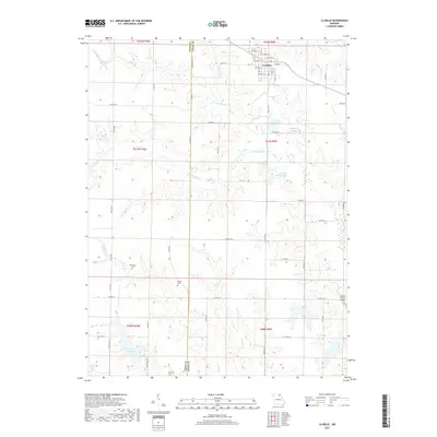
2017 Map of La Belle
USGS Topo · Published 2017About this map
La Belle serves as the central hub of this Lewis County landscape, where the town grid meets a network of state routes and country roads. The surrounding terrain is defined by a dense drainage system of creeks and branches, most notably Troublesome Cr and its tributaries like Little Troublesome Cr and Hawkins Br. This survey reveals a high concentration of family and community burial sites scattered across the rural townships, including Washburn Cem, Glover Cem, Lear Cem, and Downing Cem, offering significant value for genealogical research. Water management is a visible priority here, evidenced by several named reservoirs such as Henry Sever Lake, New La Belle Lake, and Laura M Baker Lake. The inclusion of Sharpe Farms Airport in the southeast corner points to the intersection of agricultural land use and small-scale aviation in the modern era.
Find a feature on this map
71 named features on this map. Tap any name to fly to it.
Don’t see what you’re looking for? This feature index may not catch every label — zoom into the map to look around manually.
Map Details
Editions of this 2017 La Belle Map
This is the sole edition of this map. No revisions or reprints were ever made.
Other maps of this area

1903 · Kahoka
USGS Topo · 1:125,000

1903 · Palmyra
USGS Topo · 1:125,000

1903 · Edina
USGS Topo · 1:125,000

1948 · Quincy
USGS Topo · 1:250,000

1950 · Williamstown
USGS Topo · 1:24,000

1950 · Lewistown
USGS Topo · 1:24,000

1950 · La Belle
USGS Topo · 1:24,000

1951 · La Belle
USGS Topo · 1:24,000
1951 · Lewistown
USGS Topo · 1:24,000
1951 · Williamstown
USGS Topo · 1:24,000