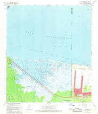
1967 Map of La Branche
USGS Topo · Published 1968About this map
Lake Pontchartrain dominates the northern half of this Louisiana landscape, where the shifting wetlands of the Mississippi River delta meet the expanding industrial and residential infrastructure of the late 1960s. The southeastern corner reveals the rapid growth of Kenner, showing a network of suburban streets such as Loyola Dr and Incarnate Word Dr emerging just north of the New Orleans International Airport (Moisant Field). This development contrasts sharply with the marshy terrain to the west, where the Bonnet Carre Floodway and the Duncan Protection Levee represent critical engineering efforts to manage the region's hydrology.
Find a feature on this map
51 named features on this map. Tap any name to fly to it.
Don’t see what you’re looking for? This feature index may not catch every label — zoom into the map to look around manually.
Map Details
Editions of this 1967 La Branche Map
3 editions found
Other maps of this area

1891 · Hahnville
USGS Topo · 1:62,500

1891 · Spanish Fort
USGS Topo · 1:62,500

1891 · New Orleans
USGS Topo · 1:62,500

1892 · Bonnet Carre
USGS Topo · 1:62,500

1932 · New Orleans NW
USGS Topo · 1:31,680

1932 · Hahnville NW
USGS Topo · 1:31,680

1932 · Hahnville NE
USGS Topo · 1:31,680

1935 · Laplace
USGS Topo · 1:31,680

1935 · Luling
USGS Topo · 1:31,680

1936 · Hahnville
USGS Topo · 1:31,680