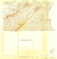
1928 Map of La Brea
USGS Topo · Published 1932About this map
The La Puente Hills dominate this survey, which captures a landscape transitioning from agricultural ranching to early industrial exploration in the late 1920s. Along the northern edge, the Union Pacific Railroad serves the settlement of Otterbein, where the Fairview School provided a focal point for local families. The interior is defined by the steep topography of Rincon de la Brea and the deep cuts of La Brea Canyon and Sonoma Canyon. While the Silver Peak Ranch suggests the area's rural roots, the presence of a solitary Oil Well near the western hills signals the arrival of the petroleum industry that would eventually transform the region. Local thoroughfares like Grazide Road and Spadra Road navigate the complex terrain, marking the early infrastructure of eastern Los Angeles County before the era of modern suburbanization.
Find a feature on this map
20 named features on this map. Tap any name to fly to it.
Don’t see what you’re looking for? This feature index may not catch every label — zoom into the map to look around manually.
Map Details
Editions of this 1928 La Brea Map
3 editions found
Other maps of this area

1894 · Pomona
USGS Topo · 1:62,500

1896 · Anaheim
USGS Topo · 1:62,500

1897 · Pomona
USGS Topo · 1:62,500

1898 · Pomona
USGS Topo · 1:62,500

1898 · Anaheim
USGS Topo · 1:62,500

1901 · Southern California Sheet No. 1
USGS Topo · 1:250,000

1901 · Anaheim
USGS Topo · 1:62,500

1902 · Corona
USGS Topo · 1:125,000

1904 · Pomona
USGS Topo · 1:62,500

1904 · Southern California Sheet No. 1
USGS Topo · 1:250,000