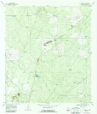
1969 Map of La Chusa Hill
USGS Topo · Published 1987About this map
The arid landscape of McMullen County comes into focus through its reliance on water and ranching infrastructure in the late 1960s. Scattered holdings like the Gueydan Ranch, Encino Ranch, and Rhode Ranch anchor the territory, connected by the unpaved corridor of Rhode Ranch Road. A dense network of windmills, including the Gueydan House Windmill, Three Corners Windmill, and Bartlett Windmills, underscores the vital importance of subterranean resources for cattle operations in this part of Texas.
Find a feature on this map
34 named features on this map. Tap any name to fly to it.
Don’t see what you’re looking for? This feature index may not catch every label — zoom into the map to look around manually.
Map Details
Editions of this 1969 La Chusa Hill Map
2 editions found
Other maps of this area

1920 · Mikeska
USGS Topo · 1:125,000

1929 · Simmons
USGS Topo · 1:62,500

1930 · Tilden
USGS Topo · 1:62,500

1937 · Loma Alta
USGS Topo · 1:62,500

1942 · Tilden
USGS Topo · 1:62,500

1953 · Crystal City
USGS Topo · 1:250,000

1955 · Crystal City
USGS Topo · 1:250,000

1961 · Crystal City
USGS Topo · 1:250,000

1968 · Crystal City
USGS Topo · 1:250,000
1969 · Live Oak Hollow
USGS Topo · 1:24,000