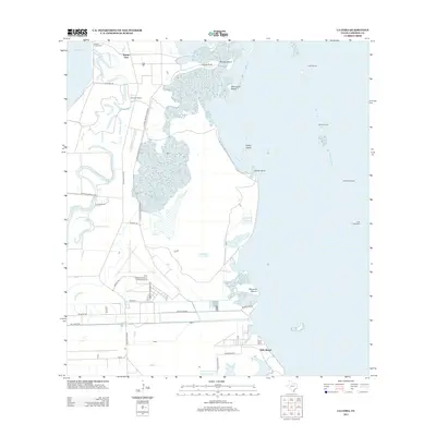
2013 Map of La Coma
USGS Topo · Published 2013About this map
The Laguna Atascosa Refuge dominates this coastal Texas landscape, preserving a complex environment of brushland, tidal flats, and wetlands along the shores of Laguna Atascosa. This 2013 survey illustrates the sparse settlement patterns typical of the lower Gulf Coast, where scattered family-named outposts like Buena Vista Ranch, Granjeno Ranch, and La Coma Ranch are situated along the interior roads. The map reveals the critical importance of water management and coastal aviation in this region, featuring the Port Isabel-Cameron County Airport alongside numerous reservoirs and lakes including Cain Reservoir 1 and Horseshoe Lake. Along the eastern edge, the transition from mainland to bay is marked by points and islands such as Stover Point and Barclay Island, while a sequence of navigational aids like Light Fiftynine and Light Sixtynine guide maritime traffic through the open waters. The small settlement at Holly Beach serves as a lone residential cluster on the edge of the wetlands.
Find a feature on this map
36 named features on this map. Tap any name to fly to it.
Don’t see what you’re looking for? This feature index may not catch every label — zoom into the map to look around manually.
Map Details
Editions of this 2013 La Coma Map
This is the sole edition of this map. No revisions or reprints were ever made.
Other maps of this area

1929 · La Coma
USGS Topo · 1:24,000

1929 · Point Isabel
USGS Topo · 1:24,000

1929 · Buena Vista
USGS Topo · 1:24,000

1929 · Laguna Vista
USGS Topo · 1:24,000

1930 · Padre Island No. 1
USGS Topo · 1:24,000

1930 · Los Fresnos
USGS Topo · 1:24,000

1930 · La Leona
USGS Topo · 1:24,000

1930 · Padre Island No. 2
USGS Topo · 1:24,000

1930 · Laguna Atascosa
USGS Topo · 1:24,000

1934 · Port Isabel
USGS Topo · 1:31,680