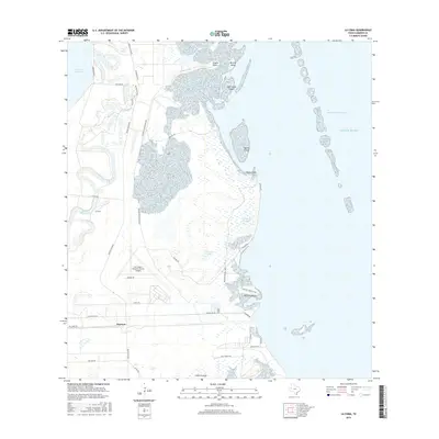
2016 Map of La Coma
USGS Topo · Published 2016About this map
Laguna Atascosa Refuge dominates this coastal landscape along the South Texas shoreline, where the land fragmentizes into a network of islands and points. This 2016 survey shows the intricate geography of Gabrielson Island, Gatlin Island, and Barclay Island separated from the mainland by narrow channels and the Intracoastal Waterway. To the west, the settlement of Bayview and the landmark Port Isabel-Cameron County Airport stand as primary hubs of activity, linked by a grid of rural roads including Center Line Rd and Buena Vista Blvd. The interior terrain is shaped by water features like Laguna Atascosa, Cain Reservoir 1, and Horseshoe Lake, illustrating the hydrology of this low-lying region. Smaller named points such as Loma La Jauja and La Coma provide specific reference points for local history within this marshy, estuarine environment.
Find a feature on this map
38 named features on this map. Tap any name to fly to it.
Don’t see what you’re looking for? This feature index may not catch every label — zoom into the map to look around manually.
Map Details
Editions of this 2016 La Coma Map
This is the sole edition of this map. No revisions or reprints were ever made.
Other maps of this area

1929 · La Coma
USGS Topo · 1:24,000

1929 · Point Isabel
USGS Topo · 1:24,000

1929 · Buena Vista
USGS Topo · 1:24,000

1929 · Laguna Vista
USGS Topo · 1:24,000

1930 · Padre Island No. 1
USGS Topo · 1:24,000

1930 · Los Fresnos
USGS Topo · 1:24,000

1930 · La Leona
USGS Topo · 1:24,000

1930 · Padre Island No. 2
USGS Topo · 1:24,000

1930 · Laguna Atascosa
USGS Topo · 1:24,000

1934 · Port Isabel
USGS Topo · 1:31,680