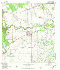
1958 Map of La Coste
USGS Topo · Published 1983About this map
The Medina River carves a winding path through this corner of south-central Texas, where the landscape transitions from the agricultural plains of the Pearson area to the more broken terrain near Rhins Hill. The settlement at La Coste serves as a central hub, anchored by the Southern Pacific tracks and the spire of Our Lady of Grace Ch. Further west, the historic Alsatian character of Castroville is evident, situated at the edge of the Flat Rock Creek valley. A critical element of the local economy is the Medina Irrigation Canal, which reflects the 20th-century engineering efforts to harness the river for the region’s farming needs. Transportation corridors dominate the north and south, with the Missouri Pacific line running through the southern reaches and the Castroville Municipal Airport serving as a modern landmark in this mid-century rural landscape.
Find a feature on this map
26 named features on this map. Tap any name to fly to it.
Don’t see what you’re looking for? This feature index may not catch every label — zoom into the map to look around manually.
Map Details
Editions of this 1958 La Coste Map
3 editions found
Other maps of this area

1942 · Natalia
USGS Topo · 1:62,500

1953 · Culebra Hill
USGS Topo · 1:24,000

1953 · Macdona
USGS Topo · 1:24,000

1954 · San Antonio
USGS Topo · 1:250,000

1957 · San Antonio
USGS Topo · 1:250,000

1958 · La Coste
USGS Topo · 1:24,000

1958 · Somerset
USGS Topo · 1:24,000

1958 · La Coste NE
USGS Topo · 1:24,000

1964 · Riomedina
USGS Topo · 1:24,000

1964 · Castroville
USGS Topo · 1:24,000