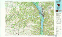
1990 Map of La Crosse
USGS Topo · Published 1991About this map
The Mississippi River corridor dominates this 1990 survey, showing the complex navigation and ecological systems where Wisconsin, Minnesota, and Iowa converge. Engineering of the river is clearly visible through Lock and Dam No 7 and Lock and Dam No 8, which manage the pools and expansive backwaters of the Upper Mississippi River Wild Life and Fish Refuge. To the west, the Root River carves through the driftless terrain of Minnesota, passing through established communities like Rushford, Peterson, and Lanesboro. The regional rail network is well-documented, featuring the Soo Line, Chicago and North Western, and Burlington Northern routes. Large conservation areas, including the Richard J Dorer Memorial Hardwood State Forest and O L Kipp State Park, define the bluffs and ridges overlooking the river valley.
Find a feature on this map
80 named features on this map. Tap any name to fly to it.
Don’t see what you’re looking for? This feature index may not catch every label — zoom into the map to look around manually.
Map Details
Editions of this 1990 La Crosse Map
This is the sole edition of this map. No revisions or reprints were ever made.
Other maps of this area

1903 · Waukon
USGS Topo · 1:125,000

1906 · Decorah
USGS Topo · 1:125,000

1909 · Sparta
USGS Topo · 1:62,500

1923 · Viroqua
USGS Topo · 1:62,500

1924 · Gays Mills
USGS Topo · 1:62,500

1926 · Gays Mills
USGS Topo · 1:62,500

1926 · Stoddard
USGS Topo · 1:62,500

1926 · Viroqua
USGS Topo · 1:62,500

1926 · North Bend
USGS Topo · 1:62,500

1927 · La Crosse
USGS Topo · 1:62,500