1958 Map of La Crosse
USGS Topo · Published 1986About this map
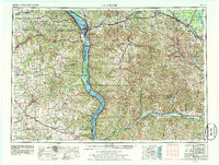
The Mississippi River and Wisconsin River dominate this mid-century landscape where Wisconsin, Minnesota, and Iowa converge. Regional hubs like La Crosse and Prairie du Chien anchor a terrain defined by deep river valleys and the unglaciated topography of the Driftless Area. Extensive conservation and military footprints are evident, from the Upper Mississippi River National Wildlife Refuge protecting the river's backwaters to the massive Fort Mc Coy Mil Res (Inactive) in the northeast. Transportation networks of the era are clearly delineated, including the Chicago Milwaukee St Paul and Pacific and Chicago and North Western railroads which followed the natural contours of the valley floors. Cultural and historical landmarks are scattered throughout, including the Effigy Mounds National Monument along the bluffs and industrial remnants like Orange Mill near the Lemonweir River.
Find a feature on this map
217 named features on this map. Tap any name to fly to it.
Don’t see what you’re looking for? This feature index may not catch every label — zoom into the map to look around manually.
Map Details
Editions of this 1958 La Crosse Map
2 editions found

Other maps of this area

1900 · Lancaster
USGS Topo · 1:125,000

1901 · Denzer
USGS Topo · 1:62,500

1901 · Oelwein
USGS Topo · 1:125,000

1901 · The Dells
USGS Topo · 1:62,500

1902 · Mineral Point
USGS Topo · 1:125,000

1902 · Elkader
USGS Topo · 1:125,000

1903 · Waukon
USGS Topo · 1:125,000

1904 · Lancaster
USGS Topo · 1:125,000

1905 · Richland Center
USGS Topo · 1:125,000

1906 · Decorah
USGS Topo · 1:125,000