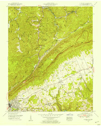
1952 Map of La Follette
USGS Topo · Published 1954About this map
Cumberland Mountain and Brushy Mountain dominate the terrain of this 1952 survey, where the extraction of coal and the development of Powell Valley define the landscape. The industrial character of the era is evident in the numerous coal operations scattered throughout Walden Hollow and near Peabody, while the regional hub of La Follette shows significant development, including the La Follette High School and La Follette Country Club.
Find a feature on this map
78 named features on this map. Tap any name to fly to it.
Don’t see what you’re looking for? This feature index may not catch every label — zoom into the map to look around manually.
Map Details
Editions of this 1952 La Follette Map
3 editions found
Other maps of this area

1886 · Cumberland Gap
USGS Topo · 1:125,000

1888 · Cumberland Gap
USGS Topo · 1:125,000

1890 · Williamsburg
USGS Topo · 1:125,000

1891 · Cumberland Gap
USGS Topo · 1:125,000

1893 · Briceville
USGS Topo · 1:125,000

1894 · Williamsburg
USGS Topo · 1:125,000

1895 · Briceville
USGS Topo · 1:125,000

1896 · Briceville
USGS Topo · 1:125,000

1897 · Maynardville
USGS Topo · 1:125,000

1900 · Maynardville
USGS Topo · 1:125,000