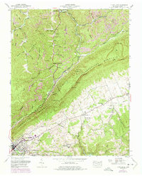
1952 Map of La Follette
USGS Topo · Published 1975About this map
The industrial and mountain landscapes of East Tennessee define this mid-century survey, where the Cumberland Mountain ridge divides the terrain. At the southern foot of the heights, La Follette serves as a principal hub, featuring landmarks like the La Follette High School and La Follette Country Club. The transition from the rugged coal-bearing ridges of Brushy Mountain to the agricultural expanse of Powell Valley is marked by numerous strip mines and small mining settlements such as Cotula, Peabody, and Kilsyth.
Find a feature on this map
70 named features on this map. Tap any name to fly to it.
Don’t see what you’re looking for? This feature index may not catch every label — zoom into the map to look around manually.
Map Details
Editions of this 1952 La Follette Map
3 editions found
Other maps of this area

1886 · Cumberland Gap
USGS Topo · 1:125,000

1888 · Cumberland Gap
USGS Topo · 1:125,000

1890 · Williamsburg
USGS Topo · 1:125,000

1891 · Cumberland Gap
USGS Topo · 1:125,000

1893 · Briceville
USGS Topo · 1:125,000

1894 · Williamsburg
USGS Topo · 1:125,000

1895 · Briceville
USGS Topo · 1:125,000

1896 · Briceville
USGS Topo · 1:125,000

1897 · Maynardville
USGS Topo · 1:125,000

1900 · Maynardville
USGS Topo · 1:125,000