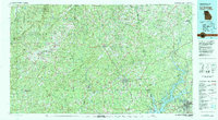
1978 Map of La Grange
USGS Topo · Published 1980About this map
Talladega Mountain and the high ridges of the Talladega National Forest dominate the western landscape of this late-1970s survey. The terrain transitions from these steep highlands into the rolling Piedmont, where the Tallapoosa River and its numerous tributaries like Ketchapedrakee Creek and Enitachopco Creek carve through the countryside. The eastern edge of the map is defined by the significant waters of West Point Lake on the Chattahoochee River, marking the border between Alabama and Georgia.
Find a feature on this map
76 named features on this map. Tap any name to fly to it.
Don’t see what you’re looking for? This feature index may not catch every label — zoom into the map to look around manually.
Map Details
Editions of this 1978 La Grange Map
This is the sole edition of this map. No revisions or reprints were ever made.
Other maps of this area

1889 · Tallapoosa
USGS Topo · 1:125,000

1889 · Springville
USGS Topo · 1:125,000

1890 · Talladega
USGS Topo · 1:125,000

1891 · Marietta
USGS Topo · 1:125,000

1891 · Ashland
USGS Topo · 1:125,000

1892 · Springville
USGS Topo · 1:125,000

1892 · Talladega
USGS Topo · 1:125,000

1892 · Tallapoosa
USGS Topo · 1:125,000

1895 · Marietta
USGS Topo · 1:125,000

1897 · Marietta
USGS Topo · 1:125,000