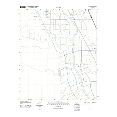
2010 Map of La Mesa
USGS Topo · Published 2010About this map
Mesilla Valley agriculture and the winding Rio Grande define this stretch of southern New Mexico. The landscape is heavily structured by an intricate irrigation system, including the West Side Canal, La Union Main Canal, and numerous laterals like the Three Saints Lateral and Chamberino Main Lateral. These waterways support a network of small communities including La Mesa, Chamberino, and Berino. Local family history is centered around landmarks such as Saint Josephs Cemetery near La Mesa and San Luis Cemetery to the south. The area's logistical importance is visible in features like the Chamberino Post Office and the Berino Siding, which sit amidst a grid of rural roads and farmsteads. Engineering projects like the Apodaca Arroyo Dam and the Pipeline Bridge underscore the ongoing efforts to manage the river and its floodplain in this productive valley.
Find a feature on this map
75 named features on this map. Tap any name to fly to it.
Don’t see what you’re looking for? This feature index may not catch every label — zoom into the map to look around manually.
Map Details
Editions of this 2010 La Mesa Map
This is the sole edition of this map. No revisions or reprints were ever made.
Other maps of this area

1891 · Las Cruces
USGS Topo · 1:125,000

1893 · Las Cruces
USGS Topo · 1:125,000

1917 · Canutillo
USGS Topo · 1:62,500

1917 · Noria
USGS Topo · 1:62,500

1918 · Noria
USGS Topo · 1:62,500

1919 · Canutillo
USGS Topo · 1:62,500

1943 · La Mesa
USGS Topo · 1:62,500

1943 · Afton
USGS Topo · 1:62,500

1953 · El Paso
USGS Topo · 1:250,000
1955 · Bishop Cap
USGS Topo · 1:24,000