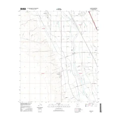
2017 Map of La Mesa
USGS Topo · Published 2017About this map
The fertile floor of the Mesilla Valley defines this agricultural landscape, where the Rio Grande is flanked by an extensive network of irrigation infrastructure. This 2017 survey shows the intricate system of laterals and drains, such as the West Side Canal, Chamberino Main Lateral, and Three Saints Lateral, that have supported farming in this region for generations. These waterworks connect a string of historic valley settlements, including La Mesa, Chamberino, and Vado. Genealogists will find the locations of Saint Josephs Cem and San Luis Cem near the town centers, while infrastructure markers like the Berino Bridge and Pipeline Bridge highlight the engineering required to manage the river's path through Doña Ana County.
Find a feature on this map
106 named features on this map. Tap any name to fly to it.
Don’t see what you’re looking for? This feature index may not catch every label — zoom into the map to look around manually.
Map Details
Editions of this 2017 La Mesa Map
This is the sole edition of this map. No revisions or reprints were ever made.
Other maps of this area

1891 · Las Cruces
USGS Topo · 1:125,000

1893 · Las Cruces
USGS Topo · 1:125,000

1917 · Canutillo
USGS Topo · 1:62,500

1917 · Noria
USGS Topo · 1:62,500

1918 · Noria
USGS Topo · 1:62,500

1919 · Canutillo
USGS Topo · 1:62,500

1943 · La Mesa
USGS Topo · 1:62,500

1943 · Afton
USGS Topo · 1:62,500

1953 · El Paso
USGS Topo · 1:250,000
1955 · Bishop Cap
USGS Topo · 1:24,000