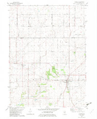
1982 Map of La Moille
USGS Topo · Published 1982About this map
The Old Indian Treaty Boundary slices diagonally across this agricultural landscape, marking a historical division that still influences local property lines and roads in the 1980s. Centered on La Moille, the map illustrates a rural Illinois community defined by its proximity to the Burlington Northern railroad and the meandering paths of Big Bureau Creek and East Bureau Creek. This area of Bureau County maintains a distinct local character through its concentration of small country landmarks, including the Bache Memorial Chapel and several family-named burial grounds like Hill Cem and St Marys Cem. The presence of a Sandpit and several pipelines indicates the local industrial and utility infrastructure that supports the surrounding farmsteads. To the northwest, the small settlement of Van Orin sits near the crossing of Van Orin Road, serving as another focal point for this well-established farming region.
Find a feature on this map
29 named features on this map. Tap any name to fly to it.
Don’t see what you’re looking for? This feature index may not catch every label — zoom into the map to look around manually.
Map Details
Editions of this 1982 La Moille Map
This is the sole edition of this map. No revisions or reprints were ever made.
Other maps of this area

1893 · Hennepin
USGS Topo · 1:62,500

1893 · Lasalle
USGS Topo · 1:62,500

1909 · Hennepin
USGS Topo · 1:62,500

1911 · La Salle
USGS Topo · 1:62,500

1911 · Hennepin
USGS Topo · 1:62,500

1913 · La Salle
USGS Topo · 1:62,500

1947 · La Salle
USGS Topo · 1:62,500

1951 · Amboy
USGS Topo · 1:62,500

1952 · Mendota
USGS Topo · 1:62,500

1958 · Aurora
USGS Topo · 1:250,000