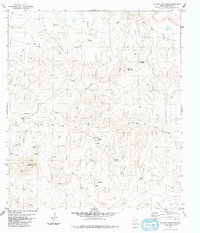
1983 Map of La Mota Mountain
USGS Topo · Published 1984About this map
La Mota Ranch and the surrounding high desert of Presidio County are documented here in the mid-1970s. This ranching landscape is defined by its critical water sources, with numerous named points such as George Windmill, Alazan Windmill, and Bull Windmill sustaining life across the arid terrain. The map captures a complex network of Jeep Trails and the Old Ranch Road that navigate the slopes of La Mota Mountain and the Alazan Hills.
Find a feature on this map
23 named features on this map. Tap any name to fly to it.
Don’t see what you’re looking for? This feature index may not catch every label — zoom into the map to look around manually.
Map Details
Editions of this 1983 La Mota Mountain Map
This is the sole edition of this map. No revisions or reprints were ever made.
Other maps of this area

1896 · Polvo
USGS Topo · 1:125,000

1896 · Shafter
USGS Topo · 1:125,000

1903 · Terlingua
USGS Topo · 1:125,000

1904 · Terlingua
USGS Topo · 1:125,000

1917 · Tascotal Mesa
USGS Topo · 1:62,500

1931 · Lajitas
USGS Topo · 1:62,500

1944 · Tascotal Mesa
USGS Topo · 1:62,500

1959 · Emory Peak
USGS Topo · 1:250,000

1959 · Presidio
USGS Topo · 1:250,000

1965 · Presidio
USGS Topo · 1:250,000